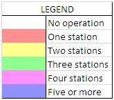
- This map is for BOTH fixed and mobile stations.
- Click in a county to see planned operations and times. Times marked with * are estimates.
- Planning reports by Bob KØRC. These reports will help you know when the county you need will be on the air. Check back because these files will be updated as mobile and fixed operations are announced or changed. The reports consist of:
- Chronology report with call signs, eta’s, and durations
- Coverage report of mobile and up to 10 fixed station call signs in each county
- Mobile Schedule report with ETA’s and durations
- Get the route & times data behind the map at MNQPData.csv
- Send your county activation plans to webmaster@w0aa.org
County outline map created using QPTools in CQ/X by NO5W
APRS tracking provided by aprs.fi

